


ORLANDO, Fla. — Tropical Depression 3, which hovered off the coast of Cape Canaveral after forming Monday over the Bahamas, has weakened into a remnant area of low pressure.
- TD3, which formed Monday off Florida, has weakened
- Low pressure in Gulf has 20% chance of development
- TRACKING THE TROPICS: Get tropical updates, forecast models, satellite loops, and more
- STORM SEASON 2019: Latest headlines, debunking hurricane myths, interactive storm tracker, printable hurricane supply checklist
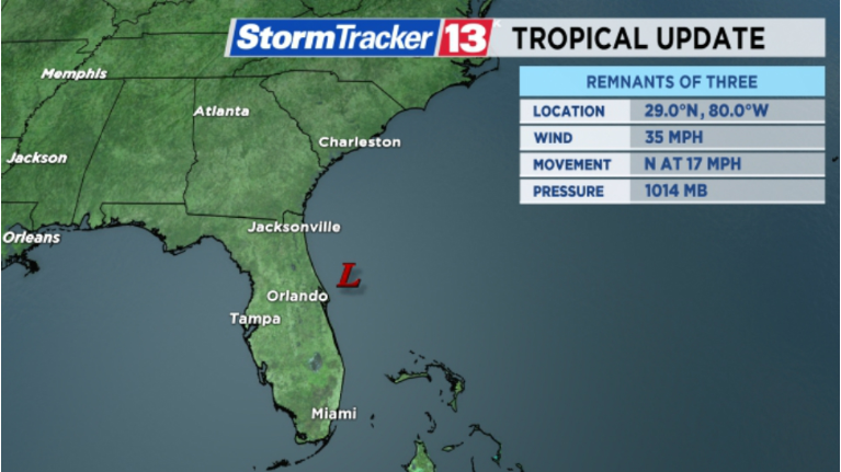
There are no big changes to our forecast for today as it skirts by our east coast, staying offshore to the east of Cape Canaveral. The area of low pressure will continue to have minimal impacts to Central Florida.

The remnants of TD3 are located about 60 miles east-southeast of Daytona Beach. The system is moving north at 17 mph. It is projected to turn north-northeast later today and pick up speed as it gets picked up by an approaching front. This front will not only steer this system but also absorb it completely by Wednesday.
Central Florida will continue to have an abundance of tropical moisture that will allow for another day with a high chance for showers and storms. Some of the storms could bring heavy rain and gusty wind. The east coast could also be breezy at times throughout the day, and those venturing offshore in small craft are urged to use caution. Other than that, no other impacts are expected.

The front absorbing the remnants of TD3 will move closer to Central Florida by Wednesday and keep our weather unsettled. High rain chances will stick around for several days.
There are some indications in the long range forecast that an area of low pressure may form along this front in the northern Gulf of Mexico later this week.
There is a 20 percent chance of development into a tropical or subtropical system over the next five days. We will be watching it closely with updates at :51 past the hour.
