


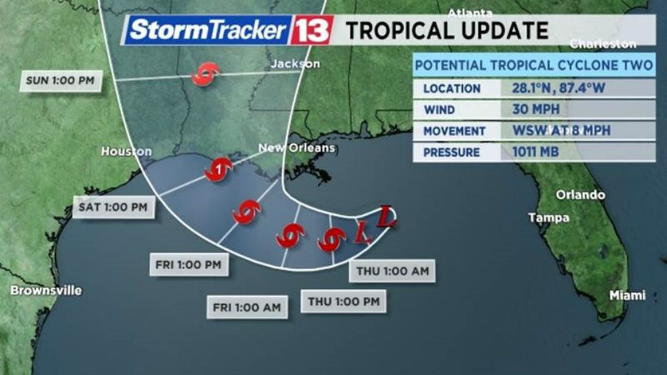
ORLANDO, Fla. — Our second tropical system of the season formed Wednesday morning in the Gulf of Mexico and is on a path west toward Louisiana or east Texas.
Potential Tropical Cyclone Two is traveling away from the Florida peninsula and will not pose a direct threat to Central Florida.
- TRACKING THE TROPICS: Get tropical updates, forecast models, satellite loops, and more
- STORM SEASON 2019: Latest headlines, debunking hurricane myths, interactive storm tracker, printable hurricane supply checklist

PTC Two is moving west-southwest at about 9 mph with winds to 30 mph.
On the latest forecast track, PTC Two is projected to gradually strengthen over the next 48 hours as it travels parallel to the coast of Mississippi and Louisiana. A turn to the northwest is likely late in the week, bringing the storm on shore into coastal Louisiana or Texas as Category 1 Hurricane Barry this weekend.

This storm will be a significant rain-maker with 6 to 12 inches and an isolated 18 inches possible in the storm’s path through early next week. In addition to the risk of flooding, storm surge flooding of 3 to 6 feet is a risk along the Gulf Coast. Isolated tornadoes could also occur in the outer bands.
A storm surge watch is in effect for:
- The mouth of the Pearl River to Intracoastal City
A hurricane watch is in effect for:
- The mouth of the Mississippi River to Cameron
A tropical storm watch is in effect for:
- The mouth of the Mississippi River northward to the mouth of the Pearl River

Central Florida will face daily rain chances for the rest of the week with scattered afternoon showers and thunderstorms, but tropical storm conditions are not expected.
Stay up to date with the tropics each hour at :51 past in Weather on the Ones.
The Atlantic hurricane season runs through November 30.

- TRACK THE TROPICS: Watches, warnings, forecasts, satellite loops, spaghetti models
- 7-DAY FORECAST: Rain chances, county-by-county temperatures
- NEIGHBORHOOD RADARS: County-by-county radar images
- THEME PARK INCLEMENT WEATHER POLICIES: Major Florida theme parks' hurricane or inclement weather policies in case of cancellations, closures