


Millions of people are dealing with active weather this week. Some are facing their biggest snowstorm of the winter, while others are basking in warmth that’s more typical of late spring.
A powerhouse winter storm blasting the Northern Plains and Upper Midwest will wind down on Thursday, although Blizzard Warnings still cover parts of the Dakotas and Minnesota. Even where the winds won’t be strong enough to cause blizzard conditions, snowfall piled up to about a foot from South Dakota through Wisconsin.
The storm led to the cancellation of hundreds of flights in Minneapolis alone Wednesday morning. The Associated Press reports that 1,800 flights were cancelled nationwide on Wednesday, and more than 6,000 were delayed.
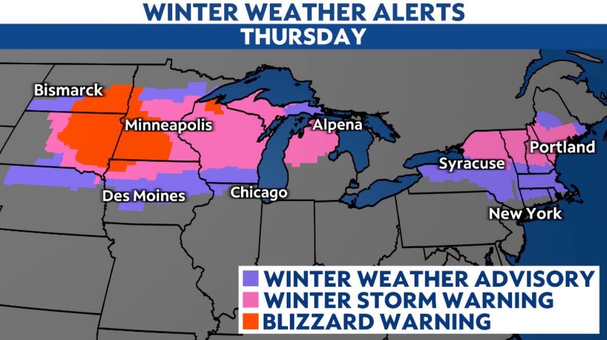
That heavy snow extends to the Northeast. A foot of snow is expected in a stripe from the northern Adirondacks of New York through central Maine.
It wasn't just not just snow that snarled travel. Freezing rain and sleet fell from eastern Iowa to southern Michigan, including the northwestern Chicago metro. Over a tenth of an inch of ice also caused tree damage and power outages.
The National Weather Service in Milwaukee issued its first Ice Storm Warning in five years.
Severe thunderstorms also hit the Middle Mississippi Valley on Wednesday. Storms led to a few dozen reports of strong winds and hail.
The West Coast isn’t getting left out of the active weather. Multiple rounds of rain and snow will buffet that region through the weekend.
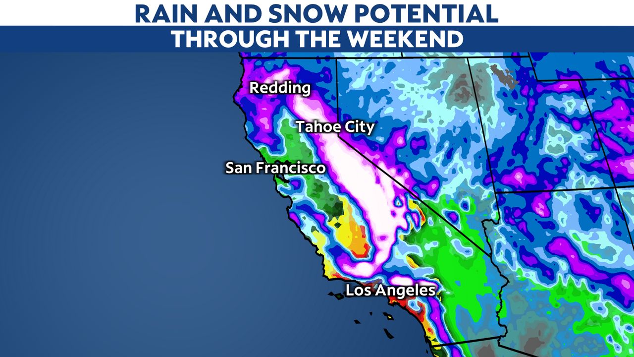
The Sierras and Southern California mountains ought to see totals top three feet. SoCal’s mountains even have a rare Blizzard Warning on Friday and Saturday as powerful winds whip up.
In fact, accumulating snow might get as low as hills of just 1,500 feet in elevation in the Los Angeles area. Coasts and valleys will deal with heavy rain and flooding.
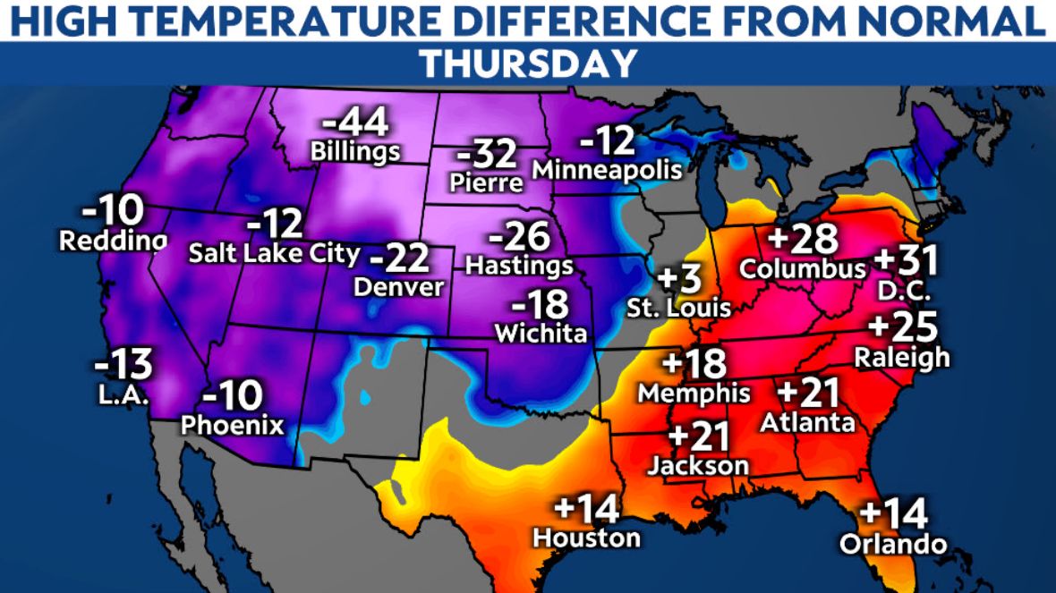
While some people dig out from big-time snow, others will bask in late-spring warmth. The Ohio Valley and Southeast will be unseasonably mild on Thursday to the tune of 15 to 30 degrees above normal.
Record highs will fall both days, but it looks like Thursday will be the record-palooza. It's not just record highs for Feb. 23 fall by the wayside, such as Washington, D.C.’s 78 degrees that was set in 1874. Record highs for February as a whole might get broken in places like Raleigh, North Carolina.
But if one region is exceptionally warm, it’s often a safe bet that another is quite cold. The entire West and Northern Plains are getting blasted by cold air. Here, too, records are falling–not just for cold morning lows, but for cold afternoon highs, as well.
Our team of meteorologists dives deep into the science of weather and breaks down timely weather data and information. To view more weather and climate stories, check out our weather blogs section.